| |
THE
NORMANDY LANDINGS
D-DAY : JUNE 6, 1944
By James Burbeck
On June 6, 1944, Allied
naval, air and ground forces operating with airborne assault troops and
paratroopers overwhelmed the German West Wall defenses built along
France's Channel Coast. Fortunately for the Allies the Germans had waited too
long to begin construction of their main defenses, and their vaunted panzer
divisions were kept away from immediate support range of the landing zone
defenders. Those armored divisions in turn lost part of their strength on the
marches to the Normandy battle zone as Allied air attacks steadily whittled
away at them. Some arrived for battle at 50% of their previous strength.
By comparison, the Allied landing forces lacked nothing, and were limited
only by the ability of their narrow man-made ports to accommodate the flood of
supplies and troops. The war machine which supplied them had focused most of
its efforts on this day, and literally millions of people had a part in its
movement. Food, equipment, ammunition, tanks, ships, guns, fighters, bombers
and a bewildering array of specialized inventions allowed the landing forces to
break through to the inland areas, where they eventually met the still
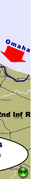
dangerous panzer divisions which were rushing toward Normandy. This animated
combat map depicts the first day of the invasion, starting with an outline of
the Allied airborne landing zones, followed by an overview of the larger German
troop and heavy gun positions which were bombarded during the landing
preparation. Finally, a progressive view of the amphibious landing force's
advance during the first 24 hours is shown along with titles of the landing
zones, combat notes and front line markers.
Anyone who has seen
Band of Brothers will be interested to know that the 506th Airborne
Infantry Regiment landed on the west side of this map, southwest of the Utah
beach landing zone. Several of Easy Company's objective cities appear on this
map, and the German paratroopers whom they fought were from the 6th Paratroop
Regiment noted on the map. |
|
